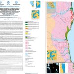
Atlante delle coste dello Stretto di Magellano –
Patagonia e Terra del Fuoco – Cile
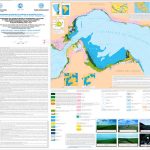
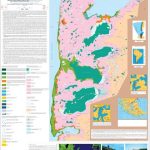
[Carta A] A. Brambati, S. De Muro, A. Di Grande (2004). Distribuzione dei terrazzi marini e transizionali (olocene) e carta geomorfologica della fascia costiera tra Bahìa Felipe e Paso Ancho, Stretto di Magellano, Cile (scala 1:200.000 – second edition).
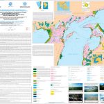
[Carta B] S. De Muro, A. Brambati, A. Di Grande (2004). Distribuzione dei terrazzi marini e transizionali (olocene) e carta geomorfologica della fascia costiera tra Punta Dungeness e Bahìa Felipe, Stretto di Magellano, Cile (scala 1:200.000 – second edition).
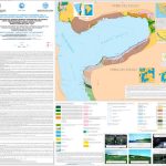
[Carta C] A. Di Grande, S. De Muro, A. Brambati (2004). Distribuzione dei terrazzi marini e transizionali (olocene) e carta geomorfologica della fascia costiera tra Porvenir e Puerto Yartou, Stretto di Magellano, Cile (scala 1:200.000 – second edition).
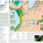
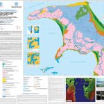
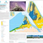
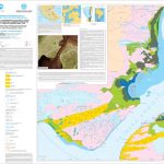
[Carta 1/12] A. Di Grande, S. De Muro, A. Brambati (2004). Distribution of the marine and transitional terraces (holocene) and geomorphological map of the coastal area between Seno Otway and Bahìa Shoal, Straits of Magellan, Chile (1:50.000 scale map – second edition).
[Carta 2/12] S. De Muro, A. Di Grande, A. Brambati (2004). Distribution of the marine and transitional terraces (holocene) and geomorphological map of the coastal area of Penìnsula Juan Mazìa, Straits of Magellan, Chile (1:50.000 scale map – second edition).
[Carta 3/12] S. De Muro, A. Di Grande, A. Brambati (2004). Distribution of the marine and transitional terraces (holocene) and geomorphological map of the coastal area between Punta Paulo e Porvenir, Straits of Magellan, Chile (1:50.000 scale map – second edition).
[Carta 4/12] S. De Muro, A. Di Grande, A. Brambati, G. Fontolan (2004). Distribution of the marine and transitional terraces (holocene) and geomorphological map of the Punta Catalina, Tierra del Fuego, Straits of Magellan, Chile (1:50.000 scale map – second edition).
[Carta 5/12] S. De Muro, A. Di Grande, A. Brambati (2004). Distribution of the marine and transitional terraces (holocene) and geomorphological map of the Primera Angostura, Tierra del Fuego, Straits of Magellan, Chile (1:50.000 scale map – second edition).
[Carta 6/12] S. De Muro, A. Di Grande (2004). Distribution of the marine and transitional terraces (holocene) and geomorphological map of the coastal area between Punta Arenas and Rio Quema Angusta, Penisula Brunswick, Tierra del Fuego, Straits of Magellan, Chile (1:50.000 scale map – second edition).
Abstract:
Previous studies, carried out by the “Dipartimento di Scienze Geologiche, Ambientali e Marine” of the “Università di Trieste”, within the “Programma Nazionale di Ricerche in Antartide” (P.N.R.A.) and by the “Dipartimento di Scienze della Terra” of the “Università di Cagliari” within the cooperation project PVS – Regione Autonoma della Sardegna – Chile on the Straits of Magellan were mainly directed at sedimentological research on the sea bottoms and coastal belt of the eastern section (Atlantic opening). Similar wide ranging research was carried out also on the coastal belt of the western section of the Straits (Pacific opening) from sea vessels, since it was inaccessible by land which is typically sheer (fiords). The first coastal studies were connected with sedimentological studies of the bottom, but were limited to research on the source and transport of the sediments as well as a regional definition of morphostructural units. Subsequent research along the coastal belt was carried out in greater detail with mapping of morphological units. During this second phase, greater attention was given to the study of palaeo-shorelines and different terrace orders of presumed marine and transitional origin (Brambati et alii 1993 a, 1993b). On the basis of the initial geomorphological, geological and sedimentological results obtained, we made a zoning of the coastal belts along the Atlantic opening of the Straits which enabled us to print three sheets on a scale of 1:200,000 (De Muro et alii 1995, Brambati et alii 1995a and 1995b, Di Grande et alii 1995). Detailed studies and maps (scale 1:50,000) of the terraced sequences linked to Holo-Pleistocene glacio-eustatic variations are in course. The Atlas, accompanied by 12 maps topographically based on 28 sections 1:50,000 scale maps (sheets 35, 50, 53, 67, 68, 69, 70, 84, 86, 101, 103 of the Chilean IGM), were made by using the preliminary cartography by Empresa Nacional de Petroleo (ENAP) and the Chilean IGM, aerial photos by Servicio Aerofotogrammetrico Fuerza Aerea de Chile (SAF) and TM and MSS Landsat satellite images. The Atlas provides a zoning of the area distribution of the most significant deposits processes and forms relating to the coastal belt between Punta Dungeness and Cabo Froward. Morphogenesis of the area was strictly controlled by the processes associated with the advance and retreat of the Magellano Glacier and, subordinately, by the main morphodynamic event represented by post deglaciation marine ingression.
The Holocene paleogeographic evolutionary picture of the Patagonia-Tierra del Fuego area is mainly controlled by the imposing phenomenon of glacio-isostasy, though it cannot be ruled out that the morphogenesis subsequent to deglaciation may have been affected by mild neo-tectonic movements. As previously observed, relative marine ingressions that produced terracing of the coasts and backland presumably depend on prevalently positive movements of the whole coastal system, related to the final deglaciation of the region. It is deduced that parallelly following deglaciation, a strong parallel uplift of the m.m. level was produced with initally transgressive stratigraphic effects. Isostatic rebound, that probably occurred rather late compared to post-glacial transgression, is superimposed with very complex and articulate phenomena, that are under study at present and will be the subject of future works.
© Università degli Studi di Cagliari
Contenuti soggetti a copyright, è vietata la diffusione e la commercializzazione.
Brambati A., De Muro S., Di Grande A. (2004) – “Atlas of the marine and transitional terraces in the Magellan Straits – Patagonia and Tierra del Fuego” – Atti del “32° International Geological Congress Florence 2004” 20-28 Agosto 2004, Firenze.

